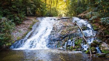
Smoky Mountain waterfalls are among the most popular natural attractions in Great Smoky Mountains National Park. From short walks to challenging hikes, visitors can find waterfalls throughout the mountains of East Tennessee and western North Carolina.
Some waterfalls are easily accessible, while others require several miles of hiking. Here are nine Smoky Mountain waterfalls worth adding to your list.
Abrams Falls
Located in Cades Cove, Abrams Falls is known for its powerful water flow despite being only 20 feet tall. The waterfall drops into a large pool surrounded by wooded scenery.
The hike is approximately 5 miles round trip and follows Abrams Creek through forested terrain. Although the elevation changes are moderate, the trail includes rocky sections and exposed roots.
Trail Distance: 5 miles round trip Difficulty: Moderate Location: Cades Cove
Grotto Falls
Grotto Falls is one of the few Smoky Mountain waterfalls where visitors can walk behind the falling water. The 25-foot waterfall is located along the Trillium Gap Trail near Gatlinburg.
The 2.6-mile round-trip hike passes through a hardwood forest and is especially popular during spring and summer. The trail can be muddy and slippery near the waterfall.
Trail Distance: 2.6 miles round trip Difficulty: Moderate Location: Roaring Fork Motor Nature Trail
Hen Wallow Falls
Hen Wallow Falls is a 90-foot waterfall located in the Cosby area of Great Smoky Mountains National Park. Rather than dropping straight down, the water spreads across a sloping rock face.
The hike begins at the Gabes Mountain Trailhead near Cosby Campground. The trail travels through a forest of hemlocks and rhododendrons before reaching a short, steep side trail leading to the falls.
Trail Distance: 4.4 miles round trip Difficulty: Moderate Location: Cosby
Indian Creek Falls
Indian Creek Falls is a 25-foot waterfall located in the Deep Creek area near Bryson City, North Carolina. The waterfall features a wide cascade flowing over several rock ledges.
The hike is approximately 1.6 miles round trip from the Deep Creek trailhead. Visitors can also see nearby Tom Branch Falls along the same route, making this a good option for seeing multiple waterfalls in one outing.
Trail Distance: 1.6 miles round trip Difficulty: Easy to Moderate Location: Deep Creek, North Carolina
Laurel Falls
Laurel Falls is one of the most recognized Smoky Mountain waterfalls. The 80-foot waterfall has upper and lower sections separated by a walkway that crosses in front of the cascade.
The trail is approximately 2.6 miles round trip and follows a paved route through the forest. Despite the paved surface, portions are steep and uneven.
Trail Distance: 2.6 miles round trip Difficulty: Moderate Location: Little River Road near Gatlinburg
Important: Laurel Falls Trail is undergoing a major rehabilitation project, with an extended closure beginning in 2025. Check the National Park Service for reopening updates before planning a visit.
Mingo Falls
Located just outside Great Smoky Mountains National Park near Cherokee, North Carolina, Mingo Falls is one of the tallest waterfalls in the region at approximately 120 feet.
The short trail includes a steep staircase with roughly 160 steps before reaching a wooden viewing bridge. Although the walk is brief, the climb can be challenging.
Trail Distance: Approximately 0.4 miles round trip Difficulty: Moderate due to stairs Location: Cherokee, North Carolina
Rainbow Falls
Rainbow Falls is an 80-foot waterfall located along the Rainbow Falls Trail near Gatlinburg. On sunny afternoons, mist from the falling water sometimes creates a rainbow near the base.
The hike is approximately 5.4 miles round trip and includes a steady uphill climb through forested terrain. The trail has rocky sections and requires more time and effort than some of the park’s shorter waterfall hikes.
Trail Distance: 5.4 miles round trip Difficulty: Strenuous Location: Cherokee Orchard area near Gatlinburg
Ramsey Cascades
Ramsey Cascades is the tallest waterfall in Great Smoky Mountains National Park, dropping approximately 100 feet over a series of rock ledges.
The trail follows rushing streams through old-growth forest, passing some of the park’s largest trees. The final section is particularly rugged, with steep terrain and rocky footing.
Trail Distance: Approximately 8 miles round trip Difficulty: Strenuous Location: Greenbrier area
Spruce Flats Falls
Spruce Flats Falls is a four-tiered waterfall located near the Great Smoky Mountains Institute at Tremont. The falls are approximately 30 feet tall and surrounded by a wooded landscape.
The trail is relatively short but includes steep, rocky sections and uneven footing. Because the route is less developed than some of the park’s main waterfall trails, sturdy hiking shoes are recommended.
Trail Distance: Approximately 2 miles round trip Difficulty: Moderate Location: Tremont
Tips for Visiting Smoky Mountain Waterfalls
Before heading out to see Smoky Mountain waterfalls, keep a few things in mind:
-
Check trail conditions: Weather, storm damage, and maintenance projects can cause temporary closures.
-
Wear appropriate shoes: Waterfall trails often have wet rocks, exposed roots, and uneven surfaces.
-
Stay out of waterfall pools: Strong currents and slippery rocks make swimming near waterfalls dangerous.
-
Allow extra time: Mountain trails can take longer than expected, particularly those with significant elevation changes.
-
Plan for parking: Popular trailheads can fill quickly, especially on weekends and during fall foliage season.
Plan Your Smoky Mountain Waterfall Hike
Whether you’re looking for a short outing or a full-day adventure, these Smoky Mountain waterfalls offer a variety of hiking experiences. Grotto Falls and Indian Creek Falls are good choices for shorter hikes, while Rainbow Falls and Ramsey Cascades provide more challenging routes.
For additional hiking ideas, see our guide to the Top 20 Smoky Mountain Hiking Trails.
Before visiting, check the National Park Service website for current trail closures and conditions.